Offshore Geological Data Released for Hsinchu and Miaoli to Accelerate Offshore Wind Development
Offshore Geological Data Released for Hsinchu and Miaoli to Accelerate Offshore Wind Development
 "Sand wave" impact potential map clearly illustrates the geological risk factors that need to be considered across different areas.
Offshore wind power is a key driver in Taiwan's transition toward green energy, and a solid geological foundation is essential for the safe operation of wind turbines. With a forward-looking approach, the Geological Survey and Mining Management Agency (GSMMA) under the Ministry of Economic Affairs(MOEA) has been conducting regional-scale geological and environmental surveys in offshore wind farm areas year by year. Following surveys in waters off Changhua, Taichung, and Penghu, the offshore geological survey of the Hsinchu and Miaoli area was completed in 2024. The fundamental geological and environmental data have now been made publicly available to wind farm developers, gradually building a comprehensive offshore wind geological database. This initiative is expected to significantly reduce the time and cost required for site investigations during the development phase, thereby accelerating the development of offshore wind power promotion.
Comprehensive Geological Surveys Lay the Foundation for Wind Farm Safety
The offshore geological survey of the Hsinchu-Miaoli area utilized a variety of detection technologies, including 10 core drillings, 786 kilometers of reflection seismic data, and 317 kilometers of high-resolution towed sonar surveys. These efforts provided a clear depiction of the seabed topography as well as subsurface geological structures and sedimentary characteristics. Given the complex geological environment in the offshore Hsinchu-Miaoli area, developers can use the data to identify or avoid geological features that could impact the stability of wind turbine foundations, thus significantly reducing the costs and timelines for follow-up geotechnical surveys and facilitating faster turbine construction.
The findings revealed widespread active geological structures in the area, including faults and anticline folds that may affect foundation stability, as well as subsurface fluid features. The crescent-shaped sand waves (submarine dunes) off the coast of Miaoli can cause changes in seabed elevation, posing potential risks to foundations. In contrast, harder strata are mainly found off the coast of Hsinchu, where attention must be paid to the heterogeneous characteristics of shallow seabed layers during foundation construction.
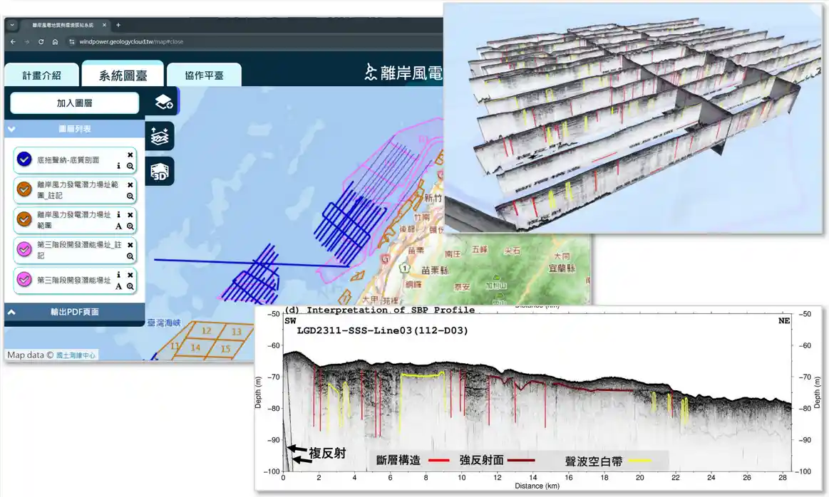 Offshore Wind Farm Geological and Environmental Sensing System: Using a seabed profile as an example, the interpretation identifies faults,
strong reflectors (hard strata), and acoustic blank zones (fluid features), while also visualizing the three-dimensional spatial distribution of geological structures.
Digital Platform Enhances Geological Awareness and Decision-Making
To integrate geological data with environmental constraints and support government policy-making and industry site planning, GSMMA has developed the “Offshore Wind Farm Geological and Environmental Sensing System” (https://windpower.geologycloud.tw/map). This platform allows users to directly download high-resolution survey images and provides detailed information on the distribution and potential impacts of geological safety factors such as faults, fluid features, sand waves, hard strata, and anticlines.
The platform also enhances the precision and visualization of risk maps, strengthening their role in informed decision-making. New features such as 3D visualization and wind power potential calculations have been added to improve planning flexibility. This geological information will aid in offshore wind farm siting and planning, ensuring stable and safe turbine operations in complex marine environments and promoting the robust development of Taiwan’s offshore wind power industry.
